


Not Again!
Thursday 22 August 2013 Another purple headed serpent lurks in the deep on Sunday, sending another 18 second swell towards the Cape coast, making landfall early on Tuesday. It was Magic Monday, now wait for Twerking Tuesday east of Agulhas! Spike writes.
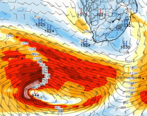
Here comes another one just like the other one. Sort of. According to the GFS wind surface charts, a beast of a storm again forms, and again, another deep energy swell sweeps towards the Cape. See the peak of the storm at 8am this Sunday 25 August around 1,600 miles from Cape Town.
The purple core of this storm looks a lot thinner and distance of the fetch mildly shorter than the storm behind the Magic Monday swell of a couple weeks ago. The swell seems around 15% less in size, and maybe a few degrees more south then the other one.
This means a better scenario for the lower SW Cape, Cape Agulhas and southern Cape region and also the Eastern Cape west of PE.
However, still a LOT of juice, and enough to get the guys frothing.
This is what Twiggy just said to me: "Spike bru ... looks like some more swell on the way, I'm so tired!!"
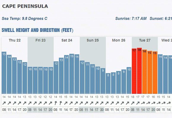
Going to be a cracker! Check the WOW models to see, but it looks like the swell comprises 18 second energy when it encounters the eastern Cape, which means that it always was 18 seconds (as it propagates away from the storm, it 'radially disperses', losing the noise of other swell in the ocean), so some epic surf in Cape Town too, or would be but for a nasty litle storm.
However, unfortunately for the Slaapstad big wave tous, a stiff NW wind blows Tuesday and a front arrives with the swell. BUT, further to the east, especially off Agulhas and into the Southern Cape and west of PE, the surf is just simply sublime in light winds. Points on fire.
Epic energy in the swell all round. Woohoo. Get that twerking on! You might need some serious negiotating skills, so why not turn it into a pole dance to get his/her attention with the view that you'll make it up some how when you get back.