


Winter Comes Alive
Wednesday 10 Aug 2011 South Africa is in for a solid spate of winter surf, with five new swells due to hit over the next 10 days, with a grinding new east swell tomorrow adding to a fat east swell already hitting the east coast, followed by a SW monster in the Cape on Saturday, reports Spike.
It's going to be a humdinger of a week y'all. Basically, we're in for (a minimum of) five swells hitting the coast from different directions and peaking at different times over the next 10 days.
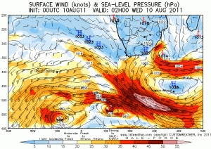
Swell # 1 - chart # 1
A weak low off 200 miles southeast of the South Coast of KZN early Wednesday interfaces with a High south of it, and a large fetch of staunch galeforce 40 knot winds lines up the East Coast, with 10-15' east swell smacking the Eastern Cape Thursday, big swell spreading into KZN as well.
SWELL # 2 - chart # 2
Meanwhile, a winter storm bears down on the southwestern Cape, hitting Cape Town on Friday, and bringing 20 foot storm seas to the region on Saturday.
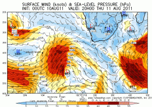
SWELL # 3 - chart # 3
After the front hits Cape Town on Friday, the storm twists on itself, reforms and catapults up the East Coast, turning into a potent galeforce buster Friday into Saturday, when a 10'+ SW swell smacks the southern extremes of the Cape, spreading into KZN late Saturday. By Sunday, Cape Town is still a solid 12'+ and it's heaving all over the coast. There's still swell, although much smaller now on Monday, to give those spaghetti arms some respite, but wait there's more. Much Moor Munch!
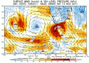
SWELL # 4 - chart # 4
From late Monday into Tuesday a large High pressure system squats to the south of PE and strengthens, peaking through Tuesday and Wednesday at an unusually strong 1041 millibars. It interfaces with a weak area of low pressure south of Madagascar, and another fierce galeforce easterly fetch kicks into gear off the KZN coast, with more east swell set to grind through from Wednesday to Friday, the focus more on the North Coast this time, but plenty reaching towards Durban and the South Coast.
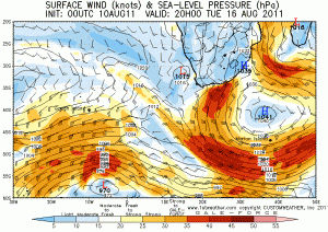
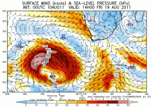
SWELL # 5 - last chart
To top off a crazy looking August (and with still 11 days to go to the end of the month), a giant winter storm is set to form on the 19th, 2000 nautical miles WSW of Cape Town, with a 30' swell expected on around the 22nd.
It's a serious one, the biggest of winter so far. We might just be in for a late flurry of wintery mayhem, as we so often do late in winter and early spring.
OTHER SWELLS in between
And of course, the above do not include the westerly twirl that forms on the other side of the High pressure system in Chart No 3 that should bring a mild west swell to the West Kus around Monday, and nor does it even bother to take into account another weaker but still significant SW storm seen bottom left of Chart No 4 from Tuesday, showing it already weakening after it peaked the day before on Monday. That swell is due to reach the SW Cape probably on Thursday.