Volatile shift in SA
Thursday 14 April 2011 The volatility of the change in seasons brings a SE gale smacking down 10 foot bombs along the SW Cape tomorrow and Saturday, while a pulsing 8' east swell pummels the East Coast from today until next week, with periods of heavy rain and strong onshores (E Cape) or rain and fresh westerly busters (KZN).
A building east swell jacked along the Wild Coast and KZN today, with Durban surfers reporting building swell all day, and fun waves along the piers. By Friday, the macking east swell (caused by 50 knot gradient winds between a low pressure cell off Madagscar interacting with a large High to the south) is peaking.
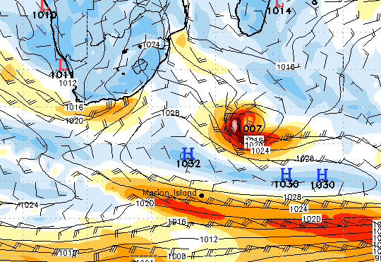
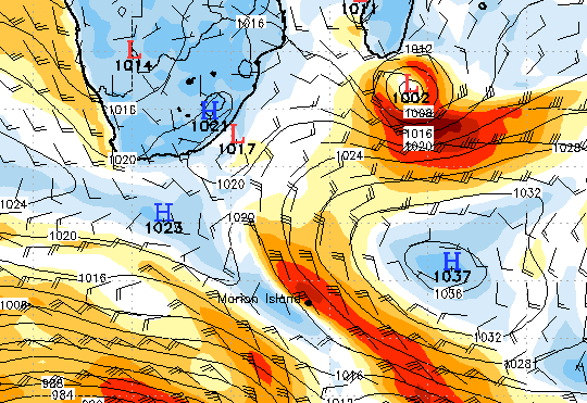
The area of wind (first diagram: a snapshot of sea surface wind at 8pm last night, Wednesday) sprays swell at the coastal area from East London to southern Mozambique, but the KZN coast cops the peak energy, and you can expect 12'+ bombs grinding with unrelenting frequency on Friday. The storm sits there, and is still churning out swell on Friday morning (second diagram, 8am Friday).
However, plenty big swell reaches into the Eastern Cape to overlay a whole bunch of deep ocean SW groundswell that peaks from the Western to the Eastern Cape on Friday from a 948 mb low pressure cell SW of Cape Town that built Tuesday and also peaked on Wednesday, just as the system to the East of the country hit its straps, creating a pincer movement to both coasts.
As the cyclone mayhem begins to peak in the East on Friday, a galeforce southeaster kaps the Western Cape Friday and really nasty on Saturday after freshening Thursday at the same time as a macking 10-12' groundswell. This solid autumn swell peaks on Friday, continuing on Saturday by which time False Bay is filling up with an 8-10' windswell at 8 seconds from the fierce SE winds that spread weaker, but strong enough, into the Southern Cape on Saturday.
The wind kills a cranking mixture of SW and east swell between Agulhas and somewhere around Mossel Bay, but further into the Eastern Cape, and especially the Wild Coast and KZN, the offshores prevail and epic surf is expected for the next few days, with expected onshores in the E Cape downgrading and offshore westerlies upgrading.