Spring Swell Burst
Tuesday 27 August 2013 Hubba Hubba. Big storms, and heavy rain, topped off by massive swell, nails the Wes and Oos Kussed as we move into spring, with 1-2 September on the East Coast copped by huge waves from a dik 967mb boil that sits 200 miles off the coast this weekend, writes Spike.
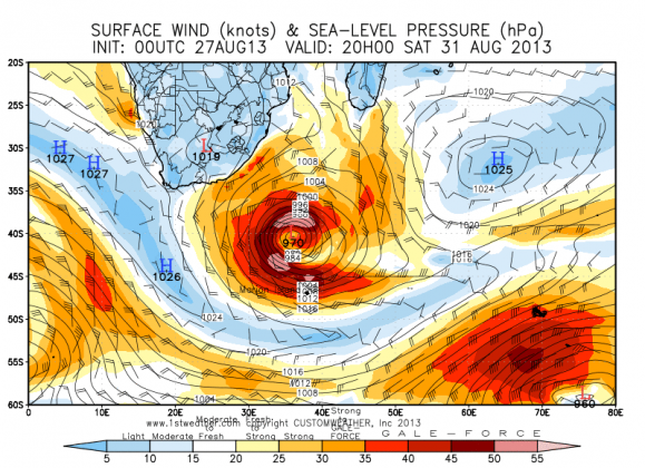
Batten your hatches furry squinchrats. Spring is about to be sprung after a coiled detonation in the deepsea. In the wake of a strong SW buster late Friday, a perfect concentric low pressure storm deepens rapidly on Saturday, then growls and spits in the same place for a full 24 hours around 200 miles southeast of Port Elizabeth.
By the early hours of Sunday, it has deepened to 965mb and an immense roiling fetch of furious wind energy is shotgun-blasting the east coast with a hooge swell.
By the early hours of Sunday, it has deepened to 965mb and an immense roiling fetch of furious wind energy is shotgun-blasting the east coast with a hooge swell. The surf builds big time in the Eastern Cape late on Sunday, peaking Monday at 20ft+ while for the Kei and South Coast of KZN, the swell builds overnight Sunday with Monday jacking all day and peaking late Monday into early Tuesday, when the piers in Durban look to be on fire.
Certainly, pretty much any point break between Cape Agulhas and Amanzimtoti is going to have a turn in being huge and out of control, barring those with sweet sticky wrappers in the Cape that will be going off!
This is the typical inter-seasonal transitional bomb blast that we have come to love and loath. Brace yourselves.
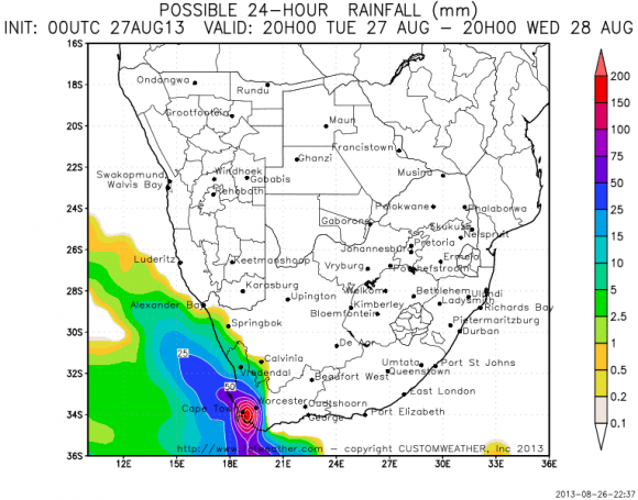
Slaapstad people, and those living in the Boland, can expect HUGE rainfalls tomorrow, Wednesday, with the worst earmarked for between 3pm and midnight. Aieyee!