


Something this Way Comes
Friday 5 July 2019 Storms are stacking up but move into westerly mode after the weekend, which is not great for the Corona JBay Open, but Spike has spotted a brute at the end of next week.
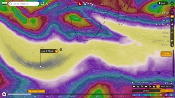
A BIT OF WIND: The jet stream tomorrow hits 208 kts at 11.7km above earth. Photo Windy
Winter shows no signs of slowing down, with a slew of storms - is that like a pod of whales or a convocation of eagles or a parliament of owls? - set to slide across South Africa's southern and eastern coast over seven days. Four to be exact.
Including the cold front from yesterday (the buster pushes past KZN today), there's a big one hitting the Cape tomorrow, another on Monday, and then one shifting south and going humungus on Wednesday (but only after it passes us). However, conditions look small or flat for the Corona JBay Open for the first half of the window period, but the second half could fire with a gigantic storm due to form 1,100 miles SSW of JBay next Saturday 13th, and another one lining up to the west of it.
After waves this weekend (JBay was 3ft yesterday and around 4ft today, getting bigger this weekend especially Sunday), the jet stream, which tomorrow indicates windspeeds of 208 kts (385km/h) out to sea below SA at 11km above the planet in the upper atmosphere, shifts towards a much more west to east trajectory, rather than bending up towards SA from the "Furious Fifties" and "Screaming Sixties".

STORM TRACK: The jet stream track then shifts away from South Africa. Photo Windy
That means that the serpetine roller coaster track of the jet stream, the tram track that surface storms tend to follow, shifts from the south to SW tangent required to light up the east coast points into a more west wind and west swell scenario.
The charts show quite a bit of swell, but it does seem that a lot will be shunted past the SA coast, particulary for the sheltered confines of points that need a lot of south in the swell direction, such as JBay. Next week, expect small waves for the Corona JBay Open, with lank westerly winds and plenty devils wind gnaw-westers.
Sure, there might be enough ambient energy in the ocean to bring plenty of fun waves to the East Coast generally, but looking at the storm tracks on the charts, it doesn't look like pumping winter swell next week. The charts suggest not a lot on the Wild Coast side or South Coast side until Sunday into Monday when some solid swell from the Cape might spread that far up. For the pros and hangers on warming up for the Corona JBay Open, this weekend has fun waves, with potentially solid waves on open coast come Sunday.

STYLE ARCH: The pros were yesterday rinsing off the jetlag with a few fun ones. Photo Grant Scholtz
But looking at the storms on the chart, and then looking at what the models on Sunday are calling a 5.5 metre swell at 13 seconds, that seems doubtful it's anywhere near that size. When there is that sort of doubt, it often means the swell disappoints, although there will be solid waves open coast.
Monday looks a smaller but fun day for the lesser known, open coast spots. And then, for the first day of the Corona JBay Open, Tuesday 9th, the swell has downgraded. It might even be too small for Supers, or small and soft 2ft maybe 3ft. But you always finds waves in winter in the Eastern Cape. Some days are just a bit bigger than others.

PURPLE PEOPLE EATER: If this storm holds like this, we're in for a helluva ride. Photo Windy
The rest of the week looks a bit dodge for the event. It's only next Saturday 13th that we see a few big storms starting to line up with good angles, and one in the deep growling as low as 938 mini-bars, which is a proper, proper storm. This is set to create a beautiful 18 second SW going SSW swell for Supers from Monday to Wednesday. Expect long lulls, with SW swell slow to pulse at first on Monday, but growing more consistent and clean on Tuesday, pending what local winds are doing of course.
This is a good sign for Supers as the jet stream shifts into a better gear again. Also cool to see Cape Town dam levels shooting up more than seven percent in a week, and while the flow may slow down, good runoff in the mountains continues with more rain ahead. Viva!