


Neptune on the Boil
Thursday 9 August 2012 You think this weekend is huge? Check the thing next week! Holy Moly! Big 40ft seas peak in Skaapstad early on Saturday afternoon, but the storm behind it is even bigger, though further away, writes Spike as his crystal ball bounces off his desk with salt-infused energy.
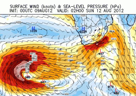
Just as the first storm bombs up the east coast, another huge bomb detonates deep in the Atlantic Ocean. This is the snapshot for 02h00 on Sunday 12 August

A big storm - one of the biggest in the last few years - hits the Cape this weekend, with fat snow dumps inland, heavy rains on the coast and dik grinding seas. A giant west swell comes off the back of a 15' SE swell that hit parts of the East Coast on Wednesday and Thursday.
Heavy rain sets in around Cape Town Friday evening as NW winds hit galeforce and the storm smashes into the coast. The rain and wind spreads into Namaqua early Saturday while also pushing deep into the southern Cape with storm-strong NW prefrontal devils wind hammering the coast, before the buster proper smears the coast with a burst of maniacal ocean energy during the day Saturday, hitting Durban early hours of Sunday.
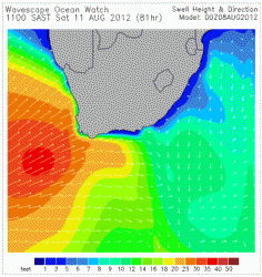
The Wavescape Ocean Watch chart (right) shows sets of 40ft x 15 seconds arriving from around 8-11am on Saturday along the SW Cape, heavy seas spreading east along the southern Cape on Saturday afternoon and overnight.
By Sunday, the deep grunt has arrived and the wind has abated, so between Cape Agulhas and Cape Recife, expect 25ft bombs x dik on open coast in calm to light leftover winds. In Cape Town, Sunday morning is a tow day, becoming maybe a paddle day as the swell subsides. Frisky NW winds blow up the face, and there's a lot of mixed bump left from Saturday's fury, but it's improving all the time.
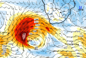
The new storm lurches into the picture in the early hours of Sunday, starting to spray a long range big pulse towards the SW Cape. Estimated time of arrival for this second big swell is Tuesday, when a 20 foot x 17 second swell arrives, and someone lights a firecracker under the Sentinel. However, the bummer is that it seems like strong winds arrive with the swell, certainly on Wednesday but hopefully Tuesday offers a window of pure filth.
To see the swell height, period and wind charts, click here