


Look What's Coming!
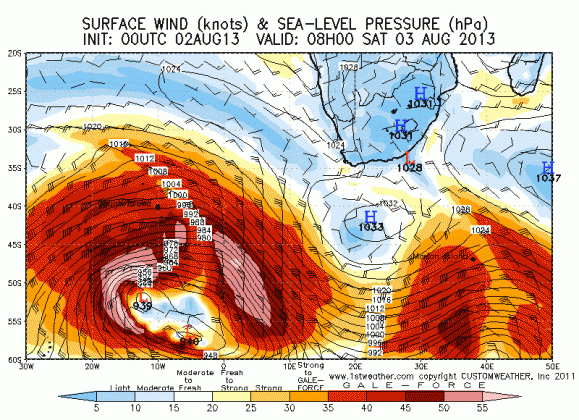
Sunday 4 August 2013 Tomorrow (Monday) promises to be a day of days in the Western Cape as a 30 foot x 19 second swell bears down from a 935mb storm that peaked 2000 miles from Cape Town on Saturday, says Spike.
Tomorrow in Cape Town looks to be a day of days. An 18 foot x 19 second swell hits Cape Town, overlaying a 15 foot west swell already running in the ocean.
This could mean some fireworks at the big wave break. My phone has run hot today with flights planned and boats booked to ride out to the open ocean reefs of Cape Town where there is going to be some serious stuff to see, or ride.
A glassy day in Cape Town but HUGE energy in the ocean so tow only unless you're riding the city breaks or False Bay. The boats are preparing for a major day on the water - i don't even want to think how big the bommie reefs are going to be ... probably 30-40 feet?
The West Coast of South Africa looks set to light up tomorrow and Tuesday - with crazy West swell everywhere and amazing grunt in this swell. Expect a few rogue deep ocean bombs. I hope the harbour authorities have issued the appropriate alerts, because this is ship anchor-dragging stuff.
This swell is going to spread up the coast to Boland, which looks 20 feet tomorrow and proper. The Southern Cape is OFF THE CHARTS good Monday, Tuesday and Wednesday but ONLY BIG WAVE Breaks. Almost too big - certainly a lot of water moving around and wild woolly seas for most normal breaks. Sheltered spots will cook. Kiff west winds too.
The J-Bay area is crazy all week, becoming downight scary at times. On Thursday, wow, it's HUGE on the EAST COAST with 10-12' SSE swell pummelling in but with weather and pumping SW busters.
KZN looks onshore this week, and barring potential cooking but brief dawnies, the onshore rules.
Tomorrow is epic for the North Coast of KZN with less onshore and more landbreeze and 15 second 6 ft S swell.
So much juice, so many days, so many waves, it's hard to focus.