


Huge Surf Advisory
Thursday 26 May 2011 A high surf advisory has been issued for the Quiksilver ISA World Junior Surfing Championships, prompting organisers to bring the last day of the event forward to Saturday to limit the youngsters' exposure to a 20ft+ swell forecast.
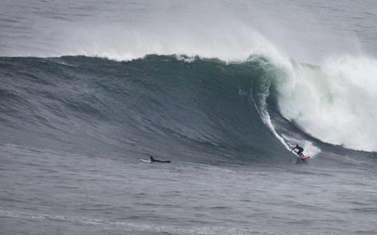
The surf is estimated to be up to 35% bigger than this bomb snagged by Team Hawaii Coach, Kahea Hart, at Pico Alto on May 17 - a few days before the start of the event.
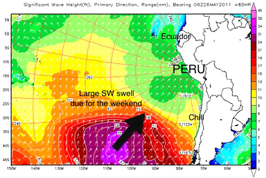
The ISA received the Official Event Surf Forecast from Surfline calling for 20+ feet on Sunday, May 29. The forecast is for 10-15 feet surf at the contest venues of Senoritas and Caballeros. At that size there is a high probability that the bay between Senoritas and Caballeros will close out, making it impossible to hold the event. The ISA has decided the will end on Saturday, May 28 at Caballeros before the swell hits.
THURSDAY 26th
SWELL/SURF: Old/easing SW swell (220-200 deg) still offers waist-chest occasional head high sets during the better tides (3-4’ occasional 5’ faces). Small, long-period forerunners of a new SW swell start to fill in under it.
FRIDAY 27th
SWELL/SURF: New SW swell (225-205 deg) gradually builds in as the old SW swell fades out. Look for the morning to already start out with chest-head high occasional overhead sets (4-5’ occasional 6’ faces), which will gradually increase through the day with plenty of overhead waves. Sets pushing double overhead+ before dark (10’+ faces). Swell peaks Friday night.
SATURDAY 28th
SWELL/SURF: SW swell (225-205 deg) holds as a new and even larger SW swell (220-200 deg) rapidly builds in. Expect well overhead surf all day with sets running double overhead++ (9-12’+ faces) through the morning. As the new swell builds in, the afternoon/evening will see larger sets pushing triple overhead+ (14-16’+ faces) before dark.
SUNDAY 29th
SWELL/SURF: Large SW swell (220-200 deg) tops out and holds with plenty of double-triple overhead++ waves, likely breaking across the bay with close-outs. Occasional larger sets on the outside up to 20’+ on the face. Exercise extreme caution.
WIND CONDITIONS
High pressure centered over the Southeastern Pacific will extend into Southern Peru and maintain southerly flow along the coast. Tuesday is expected to see moderate South winds all day. The HIGH will then weaken a bit going into the middle of the week with the mornings starting out with a light South-SSE wind, before becoming light-moderate into each afternoon and veering South-SSW. This pattern looks to continue into the weekend.
SURF SUMMARY AND LONG RANGE OUTLOOK
A fun size run of SW groundswell will hold fairly steady through the week (Tuesday through Friday), keeping up contestable surf. Meanwhile, a minor southerly windswell will continue to mix in over Tues/Wed before becoming minimal into Thursday. Although the SW groundswell will be the major wave producer during this time (Tues/Wed), the windswell will mix in small shorter period waves and create more sectiony lines for the points.
Through the past several days (and still currently underway), we have seen a large complex frontal storm system move across the South Pacific. This system has setup two solid/large overlapping swells for Peru. This first and smaller pulse (SW 225-205 deg), but still solid, will gradually build in Thursday night through Friday and top out Friday night/Saturday with double overhead++ sets. Then the second and larger pulse (SW 220-200 deg) is expected to rapidly build in Saturday and top out Sunday. Although this swell is still currently developing, it’s looking very strong! At this time, Sunday will be large/consistent and very likely maxing out Caballeros/Senoritas with 15-20’++ faces. May need to find a more sheltered/smaller location for manage-able surf for the finals