


Funso Warning
Tuesday 24 January 2012 Tropical Cyclone Funso has been upgraded to "Intense" and is one of the deadliest tropical systems to affect Mozambican waters in recent years, according to an official press release from the SA Weather Service .
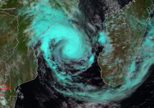
Funso briefly made landfall near Quelimane, north-east of Beira (in the Zambezia province of northern Mozambique) at the weekend, with strong, damaging winds and torrential rain lashing the region.
Buildings and infrastructure across Zambezia province were apparently devastated and as many as 12 fatalities were reported in the media. Thankfully, Funso moved out to sea again during Sunday 22nd January. However, the system was able to rejuvenate itself while moving over open water (with sea surface temperature of 29 C or more).
Over the last two days, it has deepened and become more organised, prompting classification as an “Intense” Tropical Cyclone (second only to “Very Intense” in terms of classification in the SW Indian Ocean). Strong upper-air winds (outflow jets) have developed in the upper reaches of the system, promoting further intensification at the surface. Local environmental conditions remain favourable in sustaining Funso at its current intensity, at least for the next 48hrs, perhaps longer.
With this system following close on the heels of Tropical Disturbance Dando (which, as readers will recall hit southern Mozambique and the Lowveld little more than a week ago) the public at large are naturally anxious to have fresh, reliable information regarding further predicted movement of Funso.
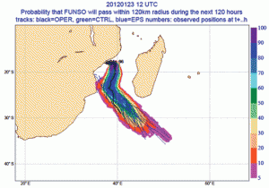
Evolution and movement of tropical cyclones worldwide are extremely difficult to predict, as they are notoriously fickle, unpredictable systems. It is quite normal for such systems (in the absence of strong steering influences, to show quite erratic movement). Whilst, to date, there has been much uncertainty regarding movement of Funso, the latest ensemble model guidance from ECMWF (European Centre for Medium term Weather Forecasts, see figure, above), is beginning to suggest an increasing likelihood that Funso is likely to remain over open water in the Mozambique Channel whilst moving predominantly southwards.
Furthermore, whilst the likelihood of Funso moving towards southern Mozambique and making landfall (still) cannot be ruled out completely, this eventuality (given the current ECMWF ensemble guidance) is judged to be less likely at this time. This is undoubtedly encouraging news for residents and holidaymakers in the Vilanculos and Inhambane area of southern Mozambique.
Notwithstanding the above, the South African Weather Service still urges the public to maintain a high level of awareness and to monitor radio and TV news updates in this regard.