


Cyclone Update
Sun 3 February 2013 KZN is bracing itself for a swell pulsing from Cyclone Felleng off Madagascar after she moved into the open ocean early Saturday. The storm provides less swell-producing time than predicted though, writes Spike.
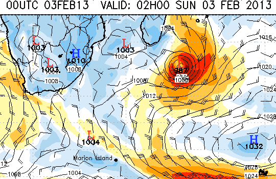
The low pressure system reached 980 mb at its peak on Saturday night before weakening. By later today, she is beginning to fade off into the southeast already.
While a trickle of swell has arrived along the coast from general east winds associated with the cyclonic interaction between the storm and a High pressure system in the south, the beginning of the main pulse arrives around 5am Monday in the form of a 6 foot East swell running at 12 second intervals, peaking at 8 feet late morning into the afternoon.
The surf on Monday comes with a strong SSW buster, making the sea wind-bitten on either side of the Bluff that will shelter Durban from the brunt of the wind.
Durban will be the place to be, with cranking waves all day. Spots outside Durban will also crank on Tuesday after the wind blows itself out, replaced by calm NW to SW offshores early in the morning, light variable W mid-morning, followed by a soft puff of easterly onshore. The swell looks 4-6' easing to 3-5'.
News agencies have reported that six people died and three were missing after cyclone Felleng barrelled down the east coast between Wednesday and Friday. With a diameter of 250 nauticl miles, Felleng packed gusts of up to 250 kilometres an hour.
Madagascar has seen 45 cyclones and tropical storms in the past decade. Cyclone Giovanna and tropical storm Irina last year killed 112 people.