


Cyclone Swell Busted
Update - Wed 22 Feb 2012 Weak east swell heads for bananaland as downgraded Cyclone Giovanna slows down and dies into the ocean off the back-end of Madagascar, while a SW buster arrives with the swell, obliterating the evidence, says Spike.
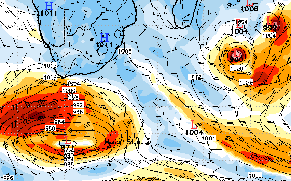
This was the forecast on Monday for today, 08h00 Wednesday 22 February 2012
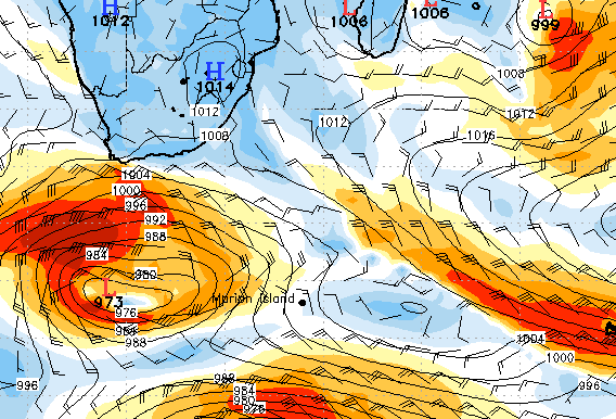
This is the forecast today for today, 08h00 Wednesday 22 February 2012
Looks like it's all downgraded drastically, with the storm now spreading out while slowing down so it doesn't really push out into the open ocean below Madagascar. When it does, the winds are downgrading. However, there is still enough fetch area and direction in the wind to create swell, just not much.
The arrival of a strong SW buster camouflages a general 3-4' east swell that trickles through from the general disturbances off Madagascar, including High pressure cells interfacing with the low pressure storm.
A solid buster-induced SSW wind- and groundswell is given prominence over the cyclone swell on Thursday, Friday and Saturday. Don't expect huge amounts of east swell to reach too far south. The focal point looks to be northern KZN and Mozambique, and when it falls within the swell window for the rest of the East Coast, the cyclone drops rapidly away and weakens.