Cyclone Swell Alert
Friday 3 January 2013 Keep a beady eye on potent east swell pulsing from Cyclone Bejisa, the first tropical cyclone of 2014, with an ETA in Durban of Monday morning, when the surf should reach 6 feet or more.
Tropical Cyclone Bejisa will first smack the French island of Réunion with big winds and heavy rain, which according to Accuweather, have already inundated the island (Saint Denis on the northern end of Reunion has had 175mm of rain and almost hurricane force winds of 65 knots).
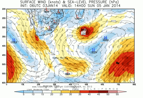
The warm waters of the Indian Ocean will enable Bejisa to keep strength into the weekend, and when she peeps out from the southern end of Madagascar late Saturday and into Sunday, she'll be packing plenty pulsing punch (899mb) with swell spraying out towards the KwaZulu-Natal coast and upper parts of the Eastern Cape. By Monday into Tuesday, she is moving SSW and weakening.
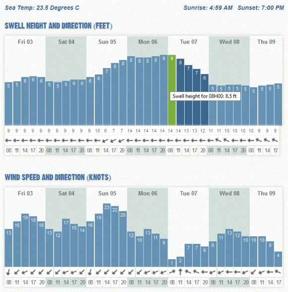
The swell is due to arrive in KZN early Monday and during the day further west into the Eastern Cape, with the strongest part of the swell showing between Monday evening and Tuesday evening. Surf is jacking Monday, and if winds are good, KZN will have waves.
However, the pick seems to be Tuesday morning which should go off just about everywhere along the East Coast with light winds forecast. Below is the Wavescape chart for Durban, but many spots between basically Port Alfred and Sodwana Bay should be firing. In terms of the easterly onshore, this is the best time, with no wind forecast.