Cyclone Boost!
Monday 17 February 2014 A mega cyclone swell is heading for KwaZulu-Natal after a tropical storm in the northern Mozambique Channel drifts past Durban on Friday and Saturday. Spike takes a squizz at his murky crystal ball.
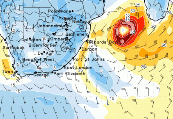
The cyclone heads south towards an area east of Durban on Friday at 02h00.
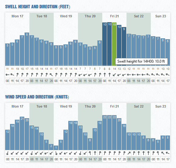
A tropical storm is developing in the northern parts of the Mozambique channel, and the charts are calling for a massive cyclone swell to hit KwaZulu-Natal this weekend, building rapidly and peaking on Friday with 20ft+ seas, and lasting through the weekend.
Friday's swell does come with a whole lot of SW wind though (tow ous in Durban on Friday afternoon?) but Saturday looks like the berries in terms of a paddleable clean cooking cyclone day of surf.
According to the following Tropical Storm Risk advisory at Cyclocane (Cyclone + Hurricane, gettit?), a favourible environment for the formation of a storm is in place:
"The area of convection previously located near 16.7S 36.7E, is now located near 17.5S 37.0E, approximately 580 nm west of Antananarivo, madagascar. recent animated multispectral satellite imagery shows shallow banding developing along the peripheries of an elongated low level circulation center (shoo! yeah man!) otherwise know as a LLCC. This disturbance lies slightly poleward of an upper level ridge axis, in an area of low vertical wind shear and favorable outflow aloft.
"The LLCC is expected to track into the Mozambique Channel during the next day, where high sea surface temperatures will support development. Multiple numerical models indicate tropical cyclone formation from this disturbance within the next few days. Maximum sustained surface winds are estimated at 20 to 25 knots. minimum sea level pressure is estimated to be near 1005 mb. Based on a favorable environment in the Mozambique Channel and multiple model development, the potential for the development of a significant tropical cyclone within the next 24 hours is upgraded to medium."
Right now, it looks like a lot of swell. Check the 11h00 model run for Durban today. Click here for updates.