Colossus Holds its Line
Wednesday 17 Aug 2011 Storm 'Colossus' holds its line for fat surf Sunday/Monday while bad winds downgrade to LEKKER light now after an expected local low pressure on Sunday peters out prematurely, reports Spike as he shivers with trepidation this morning. Latest update here
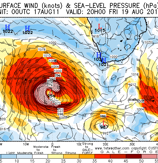
The latest model shows the storm to deepen to 950 millibars, with intense winds around its fetch peaking on Friday at 8pm.
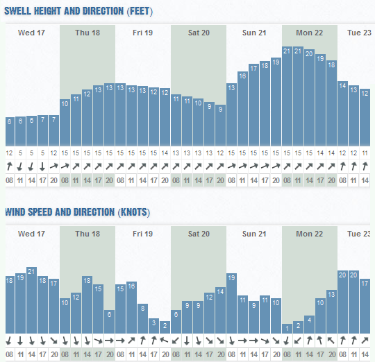
See below for the swell that actually arrives on Sunday and Monday. The height may not seem like much, but check out the period. The virtual buoy may be calling 21 feet x 15 seconds as the peak swell height, but the nearshore surf looks likely to be 25 feet at least, and I think there will be an underlying swell running at bigger sets x 18 second intervals that the charts are not picking up.
Without throwing too much hyperbole at this prediction, that's still virulently ginormous in any sane man's miserable little mind. It's getting close to the day for the charts, and the accuracy is upgraded now, with chances being it will be pretty close to current model forecasts. Another huge positive is that a low pressure due to form and bring strong manky NW winds as the swell arrives on Sunday seems to have downgraded, blowing itself out and giving way to two beautiful light wind days.
And of course Thursday and Friday are off the charts with another long range, smaller but still punchy 10-15' (open ocean) swell. Seems winds are slightly worse now, but both days have huge opportunities for excellent waves. Thursday NW is gusty with patches of light winds, while Friday the wind dies all day.
Swell height chart below taken from the Wavescape Ocean Watch report for the Cape Peninsula, which you can look at here. The WOW pages also indicate potential NEARSHORE surf heights at coastal locations within the region.