


Catastrophic Storm
Wednesday 2 February 2012 Catastrophic damage is forecast when intense cyclone Batsirai hits Madagascar on Friday, with the Mozambican and SA East Coast down to Durban on high alert late next week, writes Spike.

LAND INVASION: This snapshot of the forecast is set to 1am this Saturday. Photo Windy
Intense Tropical Cyclone Batsirai - a Shona man's name in Zimbabwe that means "someone who is born to help and serve others" - has become an extremely dangerous system as it tracks westward just north of Mauritius. While it won't directly impact Mauritius or Reunion, it's grinding past very close, with 50kt gales klapping Port Louis, worsening this evening.
The eye of Batsirai - which has deepened to 948mb and is packing 100kt (185km/h) winds will pass scarily close (90 nautical miles) to Mauritius tonight, and passes Reunion in the same vein tomorrow.
It will be serving anything but "help", only potentially catastrophic damage when it makes landfall along the east coast of Madagascar on Friday and over the weekend when it occludes or "loosens" over the land (lack of moisture to feed the mighty engine), but not by much, maybe to 990 mb, then quickly re-gathers momentum into the Mozambican Channel late Sunday into Monday.

RE-GATHERING: Cyclone Batsirai then re-intensifies in the Mozambique Channel Photo Windy
The models are bouncing around a bit so the forecast starts to get a bit murky from here. However, pertinent to southern Mozambique and the North Coast of South Africa, the ECMWF and GFS weather models both suggest that it will begin to track southward, just skirting the coast but pounding the coastal strip with savage winds and spewing out giant waves.
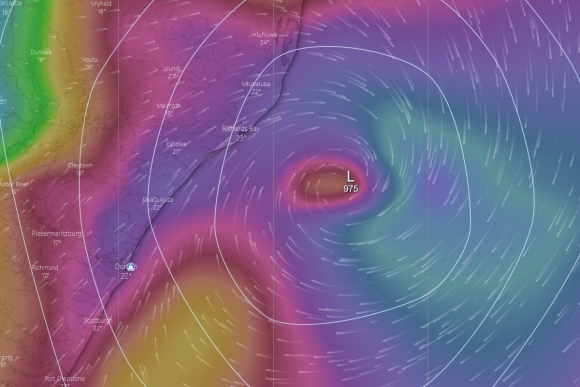
Because the eye is modelled to stay in the ocean, it does not weaken but stays in the 985mb range, even deepening to 975mb, which is strong enough for a proper big wave swell from a winter storm 2000 miles away let alone when the eye of the storm is literally tracking right over, or at least partly overlapping, the entire coastline from just southeast of Beira early next Tuesday to right on top of Richards Bay next Thursday.

OCEAN BOMB BLAST: At 2pm next Thursday Batsirai is bearing down on KZN. Photo Windy
Then its Durban's turn, with the storm pummelling the Durban coast with 50 foot seas and a hell of a gale. At first, as the storms turns clockwise on itself, winds are fresh to strong south to southeast but as the low moves south off the North Coast, Durban to Richards Bay will be getting searing SW gales (late Thursday into Friday next week).
At this point, the last part of the storm's predicted trajectory begins to diverge between ECMWF and GFS, with the latter calling the storm to track dangerously close to the North Coast and Durban before it drops harmlessly away into the southeast, while the former predicts it will drop away before it can bring such danger.
A lot can still happen though.
BATTEN THE HATCHES: By 6pm next Thursday, things could get interesting. Photo Windy

STORM SWELL: Snapshot 11pm next Thursday. Huge swell heading for the KZN coast. Photo Windy
{youtube}vI0mT4P2c6Q{/youtube}