


Boom!!
Tuesday 27 February 2018 A moer of a cyclone is forecast to appear 1,300 miles east of Durban next week Tuesday. Zulu-named Dumazile packs gusts to 105 knots. Batten the hatches, warns Spike. Swell is coming!
{youtube}mSy44GOOfFg{/youtube}
PURPLE PEOPLE EATER: Cyclone Dumazile becomes a gigantic storm. Photo Windy
Her name will be Dumazile, Zulu for "she disappoints". This may be apt - in a negative context - for residents of La Reunion, which looks set to get battered by the second cyclone of the 2018 season.
However, in the land of bananas and brus, there are signs that she will not. There is one hell of a swell heading your way if the Global Forecasting System (GFS) is to be believed. At the moment, GFS has the system modelled to form NE of Madagascar in a few days, then track south.
Currently, there is merely an innocuously jumbled area of convection called "94s" situated 500 nautical miles north of La Reunion. Scientifically based warning centre cyclocane.com said: Animated multispectral satellite imagery depicts consolidating, flaring convection"Animated multispectral satellite imagery depicts consolidating, flaring convection above a low level circulation (llc). A 271051z SSMI 85ghz microwave image shows a notch feature in the convection above the llc. 94s is aided by an upper level anticyclone creating adequate divergence aloft and low (10-15 knot) vertical wind shear."
If you know what that means, you're a better person than me. Thankfully they broke into layman's English to state that it would not form into a tropical cyclone in the next 48 hours, but beyond that, "models increasingly agree that 94s will consolidate and gain strength as it tracks to the southwest towards madagascar. However, there is still some disagreement on how fast it will move."
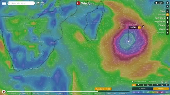
However, windy.com - armed with data from GFS - has other ideas. From this Thursday into Friday 94s becomes full blown cyclone Dumazile, tracking SW then S betweeen the coast of Madagascar and La Reunion, just slapping the latter with a side-banded swipe before moving out into the open ocean next week Tuesday. By Wednesday next week, she's going the clappers with gusts to 105 knots 1,300 miles east of Durban.
This is a bit of a heads up for you Durban ous. Let's think about some 8-10 ft waves running Friday and Saturday and Sunday next week (weekend of 10 March), and maybe bigger?
Cell C Goodwave ous, break out those 6' 6" rhino chasers.
VIRULENT BOIL: I have not seen a tropical cyclone with such a massive girth. Photo Windy