


Big Rain Coming
Mon 15 April 2013 Yikes. A deluge is heading for Cape Town and the SW Cape Tuesday and Wednesday, with massive downpours arriving with a cold front, reports Spike. Fix your roof. Break out the kayak. Could be serious flooding.
Fresh to strong NW winds blow tomorrow with nothing untowards in the morning, which looks dry along the SW Cape coast. However, from just after lunch time, thicker cloud and misty rain starts to seep in from the west, and by 8pm tomorrow night, heavy squalls are drifting over the city and heading inland, with steady rain patches from 6-7pm.
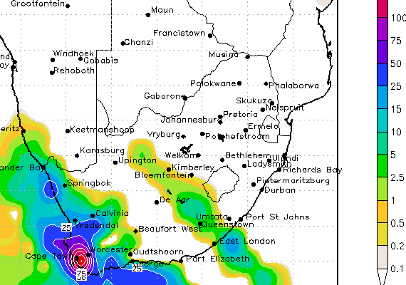
The worst, in the form of torrentially torrid rain bucketing down, can be expected between midnight on Tuesday night and 8am on Wednesday morning when the squalls are thick and furious. The rain continues to pour intermittently during the day on Wednesday, but come 8pm and there is a scary amount of rain forecast (see above rain chart snapshot from 8pm Wednesday night.
I have never seen rain like that forecast for Cape Town (only for the east coast during heavy cutoff low rain events, and some of those saw some fierce flooding).
Fix that roof. Batten that hatch. Don't water your garden.
The storm swell from the low pressure cell and frontal activity is not that exciting though, with steady increase of mucky west windswell building all day Tuesday in neargale force NW winds, still pomping on Wednesday but starting to moderate and go more westerly.
A wishy washy 4-8' storm swell can be expected at best.