


Beasterly Easter
Thurs 28 March 2013 Surfers in the Cape will gnaw choccy eggs in frustration this Easter as beastly east winds cane a solid 8ft swell, which began travelling through the ocean today from a lekker pert little low pressure nugget, writes Spike.
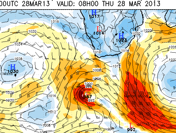
Sadly, on both sides of Agulhas, wind and swell arrive at the same time. The storm - positioned a few hundred miles SSW of Cape Agulhas at 8am this morning - spews a cranking groundswell that lasts for most of the Easter weekend.
However, sorry for you, a rapidly riding High pressure cell moers in from the west behind the current cold front, and strong east winds arrive with the swell, first in the SW Cape on Friday as 25kt SSE winds klap a building 8' groundswell, and then in the southern to Eastern Cape on Saturday when rip-force beasterlies cause a firing 6-8' SSW swell to shoot blanks.
It's not as bad in Cape Town, but the solid 8 foot swell that peaks on Easter Friday afternoon will have to work against a nasty SSE wind that steadily builds towards galeforce. The wind peaks with the peak of the swell on Saturday, a cranking 8-10' groundswell in Cape Town caned by a pure southeast gale. A bit strong to paddle into.
Meanwhile, in the Southern and Eastern Cape, Friday morning dawns SW offshore, but the swell hasn't arrived. When the swell does arrive, which it does emphatically on Saturday in the form of a perfectly directed six to eight foot SSW swell at 200 degrees - the blerry high has moved around Agulhas from Cape Town and fresh SE winds are going strong East.
By Easter Sunday, you will be gnawing on your choc Easter bunny in frustration as pumping 6-8' lines are obliterated by near-gale beasterlies.
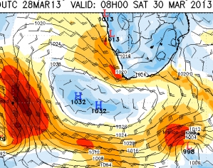
The storm reached a sea surface pressure of 987 millibars at 8am this morning, and moves slowly west to east below the country, sitting in an ideal swell generating mode from Thursday to Friday, before the fetch of the storm angles west and away from the coast, and the storm moves on into the deep.
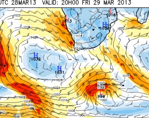
Then the massive south Atlantic High sucks in behind it, sporting surface pressure of 1033 millibars, and SE gales klap the SW Cape Friday and Saturday, and the southern Cape Saturday to Sunday.
Good news for Cape Town is that Sunday is looks kiff in light winds and glassy seas with some leftover 4' lines ebbing away if you are not wedged behind the garden shed with chocolate goo on your face and fingers.
Bad news for the Eastern Cape and KZN though. You ous are pounded by a easterlies this weekend, although Durban has kiff options, especially on Saturday and early on Sunday, which look 4'+ and clean at sunrise before the onshores come up from the south.