


Aweh Haleh!
Wednesday 6 March 2019 It's white knuckle time for the Cell C Goodwave as Intense Tropical Cyclone Haleh grinds down into Durban's swell window, but local winds are chopping and changing with each model run, writes Spike.
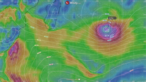
HELLO HALEH: Cyclone Haleh peaks tonight at 985mb 1,900 nautical miles from Durban.
This is by far the best looking east swell for Durban in months, if not the last two years. It has grunt. It has lulls. It is big. It is powerful. It is in the zone of epicness.
Haleh has moved into the open ocean SE of Madagascar, and has begun to track south and over the next 24 hours even moves slightly TOWARDS Africa. Good news. She will move to within 1,900 miles of Durban at the peak of her work tonight. By this time, she will be slap bang in the good zone, with a bearing of 95 degrees, the ideal direction for the new New Pier, post harbour extension.
With a central pressure of around 987mb, Haleh has peak wind gusts of 95 knots but sustained winds over a good fetch of 45 knots. In other words, Durban will start receiving a 2.8m swell at 15 second intervals on Friday, lasting the weekend and into Monday.
This probably translates to a solid 6-8 foot swell cracking along the piers in epic early morning conditions. Friday starts with a SW buster that quickly cleans up the effects of Thursday's NE beasterly onshore. Friday fires, improving all day as the swell fills in, particularly towards the low tide and into the pushing tide. Barrels cuz.
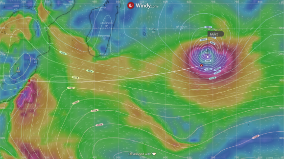
MILES AND MILES: The peak tonight at midnight indicates a 15 second swell in the making.
And then, the big question. Will the predicted east onshores puff hard enough on Saturday morning to skunk the Goodwave event? From the charts, the numbers have been upgrading and downgrading and jumping around like a flea in a box high on juju juice.
Suffice to say that when the models' can't make up their minds like this, when there is insufficient computative evidence for any particular set of conditions to be dominant, the suggestion is that no news is good news. If ever you were going to have to take a risk, this might be the time to do it.
At the moment, it shows light winds in the morning, with a hint of SE in the onshore from 10 to 11am. This could mean a glassy variable, or it might start crumbling from 9am. The NE is a devils wind for the New Pier and North so an obvious no-no, but if the models repeat themselves, that a light SE is due after the morning landbreeze, then we could be on the money. And at least you wouldn't die wanting.
Whatever happens, expect the peirs to fire every day for a minimum of the first three hours of daylight, possibly longer. And if the winds puff SE rather than NE, that means a longer window of epicness. It is similar for Sunday too, although the NE is due after a few hours of epic waves. Then the onshores bite for a few days and it seems to be done, barring dawnie feasibility.
There is time for more and for the record to be properly broken becuase the does not officially end until April 30.